Colorado Historic Markers


Northeast Colorado - High Plains Country

Cheyenne, Elbert, Kiowa, Kit Carson, Lincoln, Logan, Morgan, Phillips, Sedgwick, Washington, and Yuma Counties

Click on thumbnails to see larger images.


Kit Carson
Cheyenne County
In Kit Carson on US-40 at Kit Carson Museum.
N 38°45'52.3" W 102°47'37.7" == 38.764521N 102.793795W
photos taken 3/14/2010
           
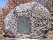
This tablet is the property of the State of Colorado.Kit Carson. Named for the great
western scout, guide, trapper, and Indian fighter. Located on famous trails - at the junction
of the Smoky Hill Stagecoach Route and the Texas-Montana, Potter and Bacon, and Chisum cattle
trails. On the old Kansas Pacific Railroad, at junction of branches running to Denver and
to Las Animas. Erected by the State Historical Society of Colorado from the Mrs. J.N. Hall
Foundation and by the Chamber of Commerce of Kit Carson. 1954.


Kiowa Country
Elbert County
In Kiowa on CO-86 at Elbert County Courthouse.
N 39°20'48.2" W 104°28'01.1" == 39.346715N 104.466978W
photos taken 3/14/2010
        
Kiowa - Trail Under Siege - Rising to the Challenge - Kiowa Country


High Plains Country
Kiowa County
In Eads on CO-96 at CDOT rest area.
N 38°28'40.8" W 102°46'44.9" == 38.478012N 102.779128W
photos taken 3/14/2010
        
Plains Indian Life - Buffalo Country - Making the Desert Bloom - High Plains Country


Sand Creek Massacre
Kiowa County
Chivington - A lone wooden sign located on CO-96 in Kiowa County east of Eads
(When in Chivington in March 2010, sign not found.)
(photo, taken in 1996, from tripod.com)

November 29, 1864, was an unforgettable day for the Cheyenne and Arapaho. On the banks of Sand Creeek, 8 miles north and 1 miles east of
here, stood a camp of about 100 Cheyenne and some 10 Arapaho lodges established, by what may have been taken as the order of the U.S.
Army Commander at nearby Fort Lyon. According to Indian tradition, early that morning Cheyenne hunters reported that soldiers were
approaching. Black Kettle, a leader and spokesman for the camp, hoisted an American Flag to convey that the camp was peaceful. Ignoring
the signal, volunteer militia, led by Colonel John M. Chivington, attacked killing all in their path. With many of the men away, organized
resistance was impossible. When the tragic day was over, more than 137 Indian people, mostly women and children, lay dead, their bodies
mutilated. The brutal attack was denounced in congressional hearings, but none of the participants was punished. Erected by the Colorado
Historical Society, the Colorado Native Council, and the … Mrs. J. N. Hall Foundation. 1986.

Sand Creek Massacre
Kiowa County
Just east of Chivington on CO-96 at intersection leading to Sand Creek National Historic Site.
N 38°26'19.4" W 102°31'40.9" == 38.438724N 102.528019W
photos taken 3/14/2010


Arriba Country
Lincoln County
South of Arriba on southwest corner of I-70 Exit 383 at CDOT rest area.
39°16'51.9"N 103°16'15.8"W == 39.281079N 103.271055W
photos taken 9/5/2022
                    
Arriba - Homesteading - Prairie Pastimes - Arriba Country

Hugo Country
Lincoln County
South of Hugo on US-40 / US-287 at CDOT rest area.
N 39°03'08" W 103°21'00" == 39.053222N 103.350000W
photos taken 3/14/2010
As of 06/13/2017, Google Maps Street View indicates the rest area and sign are gone. Nothing remains but the roadways.
           
Sand Creek Massacre - Hugo Country - Stagecoach Travel - From Horse to Tractor

Lincoln County
Lincoln County
In Hugo on US-40 / US-287 at train station.
N 39°07'58.2" W 103°27'52.3" == 39.132831N 103.464523W
photos taken 3/14/2010
        
(Similar to, but not a Colorado Historical Society sign.)
Historic Trails in Lincoln County - Welcome to Lincoln County, Home of Pioneer Hospitality!


Battle of Summit Springs
Logan County
On CO-63, 3/4 mile south of Atwood.
N 40°32'06.7" W 103°15'58.8" == 40.535183N 103.266324W
photos taken 3/29/2008
           
This tablet is the property of the State of Colorado. 13 miles southeast from this point is the site of the Battle of Summit Springs.
Last engagement with plains Indians in Colorado, July 11, 1869. Cheyennes who raided western Kansas were attacked by General
E. A. Carr with the Fifth U.S. Cavalry and Pawnee scouts under Maj. Frank North. Two white captives were held by the Indians; one
(Mrs. Alderdice) was killed. The other (Mrs. Weichel) was rescued. Chief Tall Bull and 51 Indians killed. Erected by the State Historical
Society of Colorado from the Mrs. J. N. Hall Foundatation and by Boy Scout Troop No.18 of Sterling, Colorado, 1934.

Fort Wicked
Logan County
On US-6 south of Merino, 1/2 mile north of Washington / Logan County line. Marked by "Point of Interest, 1000 feet" highway sign.
N 40°26'38.6" W 103°22'43.6" == 40.444062N 103.378783W
photos taken 3/29/2008
              
This memorial is the property of the State of Colorado. Due west 940 feet stood Fort Wicked, originally Godfrey's Ranch.
Famous Overland Stage station, one of the few posts withstanding the Indian uprising of 1864 on the road to Colorado. Named from
the bitter defence made by Holon Godfrey. Erected by the State Historical Society of Colorado from the Mrs. J. N. Hall Foundatation
and by the Sterling Chamber of Commerce, 1929.

Sterling's First Public School
Logan County
On US-138 about 2 1/2 miles northeast of Sterling.
N 40°40'34.2" W 103°09'59.1" == 40.676165N 103.166408W
photos taken 11/29/2009
This is not a History Colorado marker, but does honor Mrs. J. N. Hall
whose name appears on many of the 1929-vintage History Colorado bronze markers.
           
Sterling's First Public School. This tablet commemorates the establishment of the first public school in the Sterling
settlement, October, 1875. It was taught by Carrie G. Ayres, later Mrs. J. N. Hall of Denver. The sod schoolhouse stood
3160 feet east, and the sod fort, built by the early settlers for protection against the Indians, 4200 feet southeast of this
point. This tablet is placed by the Elbridge Gerry Chapter Daughters of the American Revolution.

Valley Station
Logan County
1 1/4 miles southeast of Sterling and 1/4 mile north of I-76 on US-6 at the Overland Trail Museum.
N 40°37'06.6" W 103°10'52.6" == 40.618489N 103.181275W
photos taken 3/29/2008
              
This tablet is the property of the State of Colorado. 3.8 miles north along country road is the site of Valley Station.
Built in 1859 as a stagecoach station of the Leavenworth and Pikes Peak Express. Station on the Overland Trail to California,
1862-67. Indian war outpost, 1864-65. Once defended by a breastwork of sacks of shelled corn. Erected by the State Historical
Society of Colorado from the Mrs. J. N. Hall Foundatation and by Troop No. 16, Sterling Scouts, B.S.A., 1933.


Colorado
Phillips County
East of Holyoke on US-6, 1/2 mile west of state line.
N 40°35'08.7" W 102°04'04.2" == 40.585747N 102.067828W
photos taken 4/19/2010
                 
Making the Desert Bloom - Settling the Plains - Welcome to Colorado - Colorado Border Country


Colorado
Sedgwick County
In Julesburg, on north side of US-183 (1st St) between Oak and Elm Streets. Sign was erected in 1956.
N 40°59'15.1" W 102°15'38.9" == 40.987541N 102.260803W
photos taken 4/3/2008
              
Entering the Centennial State. Colorado. Here on the Great Plains where the ramparts of the Rocky Mountains still lie some
hours westward, the mountain state welcomes you. This highway leads up the valley of the South Platte River to Denver. In 1859 and
1860 the gold rush carried thousands westward along this trail, in wagons, on horseback, with handcarts and on foo, seeking fortune.
They saw then an empty land, traversed only by nomad Indian bands who followed great dark herds of buffalo, often miles in extent.
Towns like Julesburg soon grew from stage stations armed against Indian attack. In the 1870's the first rails were laid almost in
the wagon ruts. Today the highway traverses bountiful lands and substantial cities.

Pony Express
Sedgwick County
In Julesburg, on south side of US-183 (1st St) between Pine and Walnut Streets.
N 40°59'08.5" W 102°15'48.8" == 40.985685N 102.263547W
photos taken 4/3/2008
These are not History Colorado markers, but honor the Pony Express.
        
The Pony Express. 1860-1861, 1960-1961. Sacramento, Friday's, Salt Lake City, Julesburg, Ft. Laramie, Ft. Kearney, Marysville,
St. Joseph. Julesburg, Colorado. Jules Beni, after whom Julesburg is named, was the station master for the Pony Express and
Overland Stage. He was kiled by Jake Slade, who later became a notorious gunman. Erected by the Fort Sedgwick Historical Society.
National Pony Express Centennial Association. Dwight D. Eisenhower - Chairman, Waddell F. Smith - President.

The Pony Express. 1860-1861, 1960-1961. 120 celebrated riders. Rode 650,000 miles with only one rider killed by Indians, one
schedule not completed and one mail lost. Russell, Majors, Waddell, founders, owners, operators. Sacramento, California, Friday's Station,
Nevada, Salt Lake City, Utah, Ft. Laramie, Wyoming, Julesburg, Colorado, Ft. Kearney, Nebraska, Marysville, Kansas, St. Joseph, Missouri.
National Pony Express Centennaial Assn.. Dwight D. Eisenhower - Chairman, Waddell F. Smith - President, Eugene T. Hogue - Director
at large, James Stretesky - Vice Pres.

Colorado
Sedgwick County
South of Julesburg at I-76 rest area.
4-panel sign == N 40°57'57.7" W 102°15'05.6" == 40.966016N 102.251546W
Pony Express statue == N 40°58'00.0" W 102°15'03.9" == 40.966663N 102.251095W
photos taken 12/27/2008
        
Welcome to Colorado - Julesburg Country - Colorado's Wildlife Story - Last Days of the Buffalo

           
Great Western Trail - James Stretesky Memorial Hill - The Pony Express Trail

Colorado's Northeast Corner
Sedgwick County
From I-80 Exit 107 (Big Springs, NE), 3 miles south on road 209, 1 mile east on road 36.3 / 2 (Colorado / Nebraska state line).
N 41°00'08.5" W 102°03'05.7" == 41.002359N 102.051576W
photos taken 3/29/2008
                    
           
This tablet is the property of the State of Colorado. Colorado's Northeast Corner. The organic act creating the Territory of
Colorado was signed by President Buchanan on February 28, 1861. The act carved from the Territories of Kansas, Nebraska, Utah, and
New Mexico the 104,247 square miles that became the 38th state in 1876. The original survey establishing this boundary point was
completed by Oliver N. Chaffee on October 7, 1869 and recorded on a six foot limestone shaft set in a circular earth mound centered
at the intersection of the 25th meridian west from Washington, D.C. and the 41st parallel north from the equator. At its time of
replacement in 1976, the broken shaft, orginally inscribed on the north, 25 W.L; east, Nebraska; west 41 N.L.; and south, 68 M.79 CH.
and 59 LKS (the distance between the 40th and 41st parrallels) was badly eroded. When resurveyed, the new inscription cited the now
standard Greenwhich reference for the longitudinal measurement. Erected by the State Historical Society of Colorado and the people of
Sedgwick County through the Mrs. J. N. Hall Foundatation, 1977.

Fort Sedgwick
Sedgwick County
At eastern edge of Ovid, on south side of US-183.
N 40°57'38.8" W 102°23'02.7" == 40.960786N 102.384082W
photos taken 4/2/2008
           
This memorial is the property of the State of Colorado. Due south 1 1/4 miles is the site of Fort Sedgwick. Established in
September, 1864, as a United States Army post. Called Camp Rankin and Post Julesburg. Name changed in November, 1865, to honor
General John Sedgwick, who was killed at Spottsylvania May 9, 1864. The fort protected the stage line and emigrant trains from Indians.
Abandoned in May, 1871. From this fort Sedgwick County derives its name. Erected by the State Historical Society of Colorado from
the Mrs. J. N. Hall Foundatation and the Julesburg Historical Society, 1940.

Old Julesburg
Sedgwick County
From Ovid, 1.5 miles south on road 27 (or just north of I-76, exit 172), then 1.5 miles east on road 28.
N 40°56'19.9" W 102°21'42.1" == 40.938874N 102.361702W
photos taken 4/3/2008
                    
This memorial is the property of the State of Colorado. Due north 1235 feet is the original site of Old Julesburg. Named for
Jules Beni, whose trading post was established at the "upper crossing" of the Platte prior to 1860. Junction of Oregon and Overland
Trails. Pony express station 1860-61. Overland stage station 1859-65. Burned in Indian raid Feb 2, 1865. Erected by the State Historical
Society of Colorado from the Mrs. J. N. Hall Foundatation and by the citizens of Sedgwick County, Colorado, 1931.


Akron Country
Washington County
In Akron on US-36 at west edge of town.
N 40°09'32.3" W 103°13'02.1" == 40.158981N 103.217249W
photos taken 4/19/2010
              
Akron - Indian Wars 1864-1869 - Last Days of the Buffalo - Akron Country

Summit Springs Battlefield
Washington County
South of Atwood. From I-76, exit 115, south 4.7 miles on CO-63 (county line, marked by "Point of Interest, 5 Miles" highway sign),
then 3.9 miles east on CR-60 to corner where private road was chained off on 3/29/2008.
Then east about 0.5 mile, then south about 0.2 mile on private road marked by "Private road, not responsible for injury or accident." and "Summit Springs" signs.
Point at which private road was closed. == N 40°26'12.8" W 103°09'00.4" == 40.436893N 103.150104W
Approximate location of marker. == N 40°26'00.3" W 103°08'27.7" == 40.433404N 103.141017W
photos taken 3/29/08
        
This tablet is the property of the State of Colorado. Summit Springs Battlefield. Fleeing after a series of bloody raids on
the Kansas frontier, a band of 450 marauding Cheyenne dog soldiers led by Tall Bull (Tatonka Haska) camped here. On the afternoon of
July 11, 1869, 300 men of the 5th Cavalry and the Pawnee scouts under Gen. E.A. Carr made a successful surprise attack on the camp.
Chief Tall Bull was among the 52 Indians killed in the battle; 418 horses and mules were captured, and 84 lodges wer put to the torch.
Fifth Cavalry scout Buffalo Bill Cody later made this last Plains Indian battle in Colorado a regular feature of his Wild West Show.
Erected by the State Historical Society of Colorado from the Mrs. J.N. Hall Endowment Fund and by the Sterling Lions Club and the
Logan County Commissioners, 1966.


Colorado
Yuma County
East of Wray on US-34, 1 mile west of state line.
N 40°04'21.8" W 102°04'15.1" == 40.072712N 102.070866W
photos taken 4/19/2010
              
Entering the Centennial State, Colorado. Here, near the springs of the Republican River, you enter the Mountain State. In the
center of the Great Plains, these prairies once called the American desert. And the wall of the Rocky Mountains to the west once
barred the advance of the white man. Here, in unbelievable numbers, grazed buffalo and shy swift antelope. Indians on horseback,
with their tee pees tied on dragging poles, raided the buffalo herds for meeat and hides. Today, highways railroads and airplanes
carry the traveler in a few minutes, further than ox-hauled wagons reached in a day. Colorado is one of the last settled areas of
America. Today, over 3,000,000 residents inhabit its plains, mountains, and cities, surrounded by varied agriculture industry,
scenery, and climate. Colorado welcomes you.
(Note, the "3,000,000" has been changed several times over the years.)

Yuma Country
Yuma County
Two miles east of Yuma on US-34.
N 40°07'08.2" W 102°39'37.6" == 40.118947N 102.660446W
photos taken 4/19/2010
                    
Yuma - Battle of Beecher Island - Yuma Country - Greater Prairie Chickens


Back to Colorado Historic Markers page
Back to Pass Bagger page

© 2008-22 Randy Bishop
Last modified: September 17, 2022