
Colorado's Northeast Corner
|
Colorado's Northeast Corner |
Northeast corner of Colorado - Sedgwick County - Colorado - 3,615 feet
4-county corner of Colorado's Sedgwick County and Nebraska's Deuel, Keith and Perkins Counties
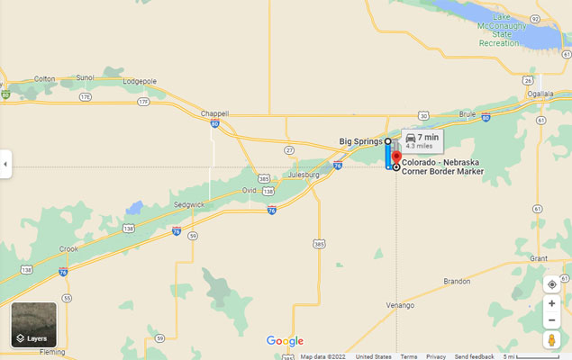
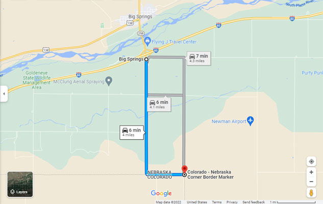
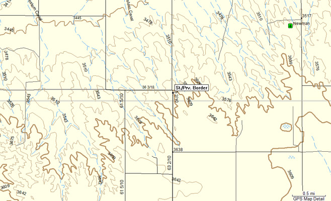
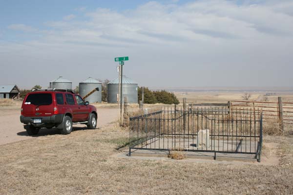
From I-80 Exit 107 (Big Springs, NE), 3 miles south on Rd 209, 1 mile east on Rd 36.3
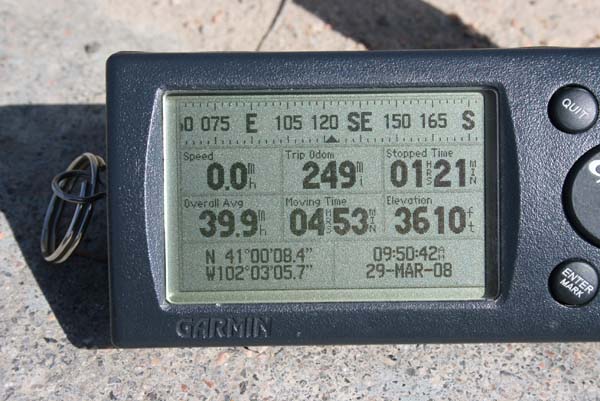
41°00'08.5"N 102°03'05.7"W == 41.002360N 102.051580W
gravel - dual sport or road bike
photos by John Coker, 05/06/2014
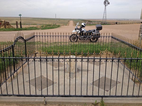
at the corner, looking west |
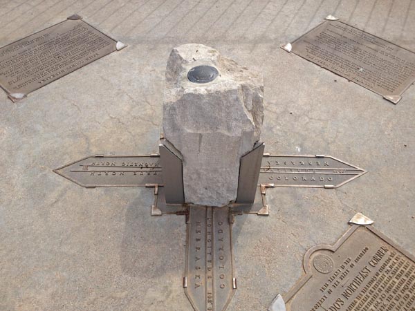
geodetic survey disk |
Google Maps |
Google Maps |
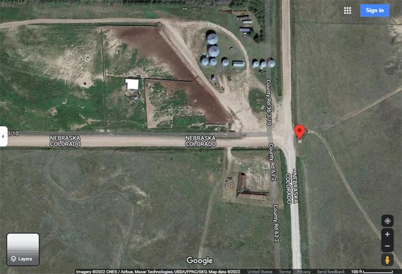
Google Maps |
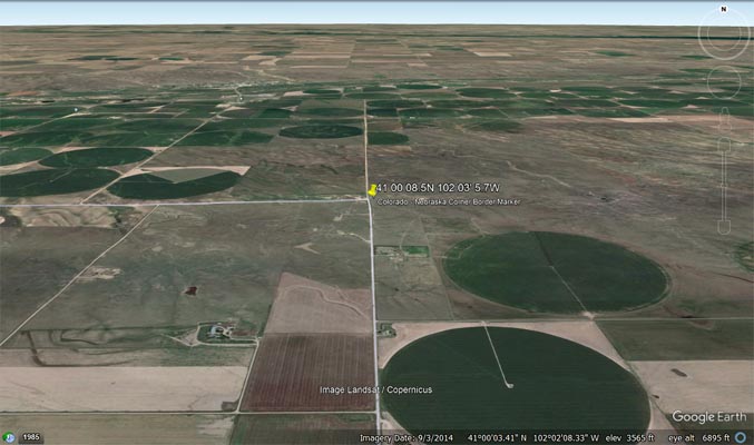
Google Earth |
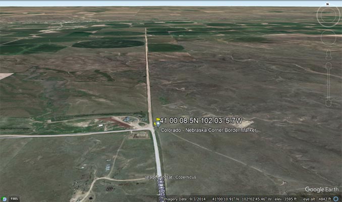
Google Earth |
Garmin MapSource |
photos by Randy Bishop, 03/29/2008
at the corner, looking north |
at the corner, looking northeast |
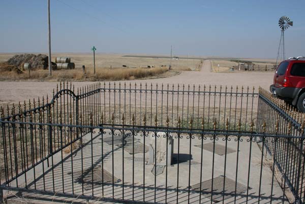
at the corner, looking west |
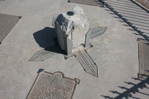
geodetic survey disk |
geodetic survey disk |
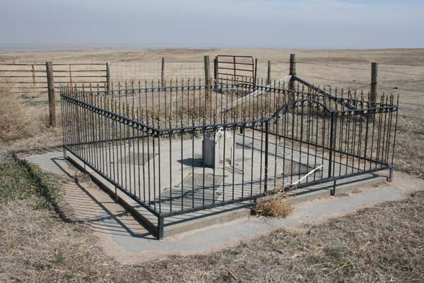
Colorado's Northeast Corner |
Sedgwick County |
Deuel County |
Keith County |
Perkins County |
at the corner |
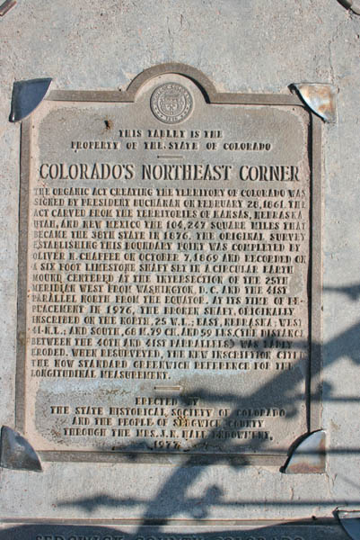
The Colorado historical marker next to the post reads:
This tablet is the property of the State of Colorado. Colorado's Northeast Corner. The organic act creating the
Territory of Colorado was signed by President Buchanan on February 28, 1861. The act carved from the Territories
of Kansas, Nebraska, Utah, and New Mexico the 104,247 square miles that became the 38th state in 1876. The original
survey establishing this boundary point was completed by Oliver N. Chaffee on October 7, 1869 and recorded on a six
foot limestone shaft set in a circular earth mound centered at the intersection of the 25th meridian west from Washington,
D.C. and the 41st parallel north from the equator. At its time of replacement in 1976, the broken shaft, orginally
inscribed on the north, 25 W.L; east, Nebraska; west 41 N.L.; and south, 68 M.79 CH. and 59 LKS (the distance between
the 40th and 41st parrallels) was badly eroded. When resurveyed, the new inscription cited the now standard Greenwhich
reference for the longitudinal measurement.
Erected by the State Historical Society of Colorado and the people of Sedgwick County through the Mrs. J. N. Hall Foundatation, 1977.
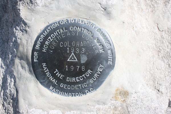
The geodetic survey disk reads:
For information or to report damage write The Director, National Geodetic Survey, Washington, D.C.
Horizontal Control Mark. Northeast Corner. Colorado 1933 (triangle symbol) 1978.
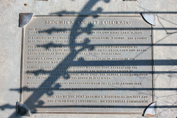
The Sedgwick County Colorado plaque reads:
The northeastern most county in Colorado was first Weld County, later Logan County and established in its own right
April 9, 1889. It consists of 554 square miles, incorporating 3 towns: the county seat, Julesburg, Ovid and Sedgwick.
The cattle industry developed then irrigation contributed to agricultural crops such as sugar beets, small grain, corn
and beans. Later, circular irrigation spread to the tablelands. Sedgwich County was the first in the state to be served
by the Union Pacific Railroad. Famous trails through the county wer the pony express and the military road to Laramie,
crossing the South Platte River at the upper California crossing near Ovid. The Denver road continued west on the south
side of the South Platte River. Buffalo once abundant disappeared from the plains around 1880.
In commemoration of ouir forefathers and citizens.
Erected by the Fort Sedgwick Historical Society and the Colorado Centennial-Bicentennial Commision. September 24, 1976.
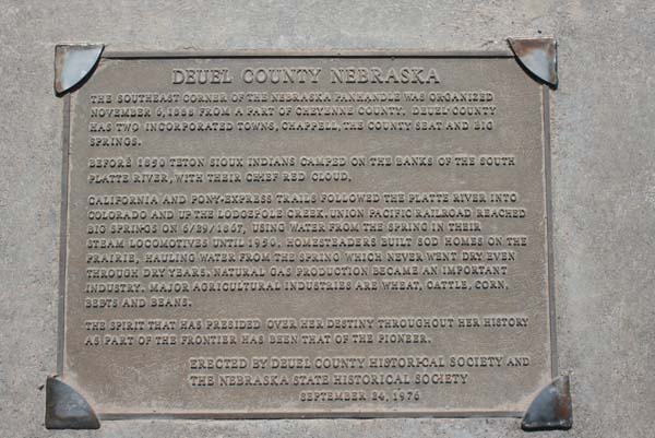
The Deuel County Nebraska plaque reads:
The southeast corner of the Nebraska panhandle was organized November 6, 1888 from a part of Cheyenne County. Deuel County
has two incorporated towns, Chappell, the County Seat and Big Springs. Before 1850 Teton Sioux Indians camped on the banks
of the South Platte River, with their chief Red Cloud. California and Pony Express Trails followed the Platte River into
Colorado and up the Lodgepole Creek. Union Pacific Railroad reached Big Springs on 6/29/1867, using water from the spring in
their steam locomotives until 1950. Homesteaders built sod homes on the prairie, hauling water from the spring which never
went dry even through dry years. Natural gas production became an important industry. Major agricultural industries are wheat,
cattle, corn, beets and beans. The spirit that has presided over her destiny throughout her history as part of the frontier
has been that of the pioneer.
Erected by Deuel County Historial Society and the Nebraksa State Historical Society. September 24, 1976.
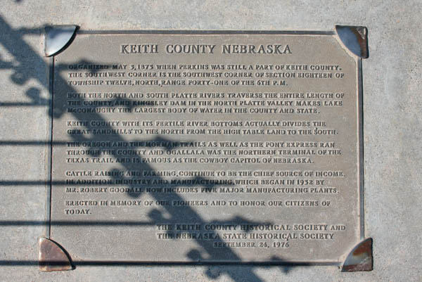
The Keith County Nebraska plaque reads:
Organized May 3, 1875 when Perkins was still a part of Keith County. The southwest corner is the southwest corner of section
eighteen of township 12, north range forty-one of the 6th P.M. Both the North and South Platte Rivers traverse the entire length
of the county, and the Kingsley Dam in the North Platte Valley makes Lake McConaughy the largest body of water in the county and
state. Keith County with its fertile river bottoms actually divides the great sandhills to the north from the high table land to
the south. The Oregon dn the Morman Trails as well as the Pony Express ran through the county and Ogallala was the northern
terminal of the Texas Trail and is famous as the Cowboy Capitol of Nebraska. Cattle raising and farming continue to be the chief
source of income. In addition industry and manufacturing, which began in 1932 by Mr. Robert Goodall, now includes five major
manufacturing plants.
Erected in memory of our pioneers and to honor our citizens of today.
The Keith County Historical Society and the Nebraska State< Historical Society. September 24, 1976.
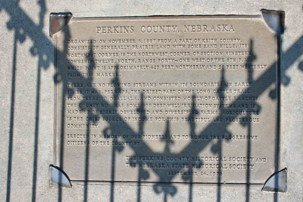
The Perkins County Nebraska plaque reads:
Organized on November 8, 1887 from a part of Keith County. Consists of generally prairie land with some sand hills. its northwest
corner is the northwest corner of section nineteen, township twelve, north, range forty-one west of the 6th P.M., which point is
approximately 425 feet northerly and 50 feet westerly from this marker. There are no flowing streams within its boundaries. In early
times it was, perhaps, the driest part of the long cattle trail from Texas to Ogallala, and consisted mostly of cattle ranches. The
county now has some 500 deep well irrigation systems and is made of highly developed and diversified farms. Agriculture is the chief
source of income for the beautiful and prosperous community.
Erected in memory of our pioneers and to honor the progressive citizens of the county.
The PerkinsCounty Historical Society and the Nebraska State Historical Society. September 24, 1976.
For more Colorado historical markers on the passbagger.org site, click here.