
Colorado's Northwest Corner - CO-UT-WY Tripoint
|
Colorado's Northwest Corner - CO-UT-WY Tripoint |
Tripoint of Colorado, Utah, and Wyoming
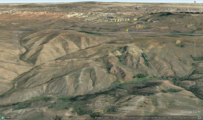
Northwest corner of Colorado - Moffatt County - Colorado - 8,402 feet
Northeast corner of Utah - Daggett County - Utah
Southern border of Wyoming - Sweetwater County - Wyoming
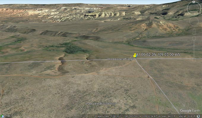
41°00'02.3"N 109°03'00.4"W == 41.000638N 109.050111W
A suggested route is:
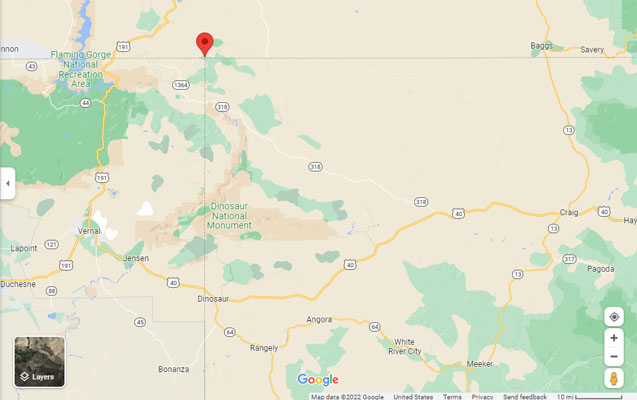
Starting in Maybell == 40°31'00.6"N 108°05'40.5"W == 40.516826N 108.094579W
60 miles on CO-318 to stateline == 40°51'43.0"N 109°02'56.0"W == 40.861935N 109.048885W
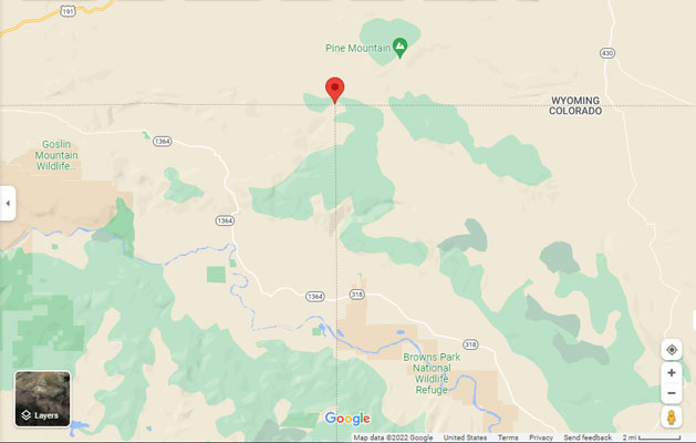
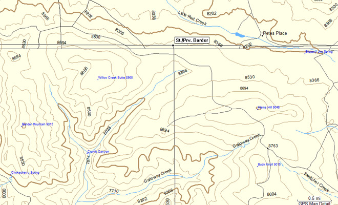
12 miles on UT-1364 / Browns Park Rd to Three Corners Canyon Rd intersection == 40°57'49.3"N 109°09'32.6"W == 40.963682N 109.159059W
1.7 miles on Three Corners Canyon Rd to Willow Creek Rd intersection == 40°57'49.4"N 109°07'40.9"W == 40.963727N 109.128023W
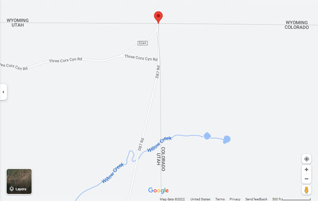
3.4 miles Willow Creek Rd to D87 Rd intersection == 40°57'54.3"N 109°04'46.6"W == 40.965086N 109.079623W
3.4 miles on D87 Rd to tripoint == 41°00'02.3"N 109°03'00.4"W == 41.000638N 109.050111W
An alternate route is north on US-191 from Vernal, Utah, then east to the tripoint.
paved, gravel, dirt - dual sport
photos by John Coker, 06/06/2014
At the corner. |
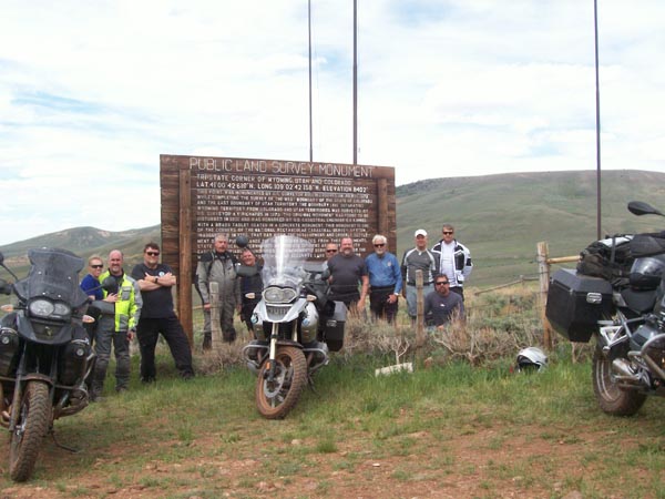
At the corner. |
Google Maps |
Google Maps |
Google Maps |
Google Maps |
Google Maps |
Google Earth |
Google Earth |
Garmin MapSource |
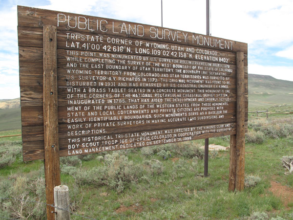
The sign reads:
Public Land Survey Monument.
Tri-state corner of Wyoming, Utah and Colorado.
Lat. 41° 00' 42 616"N. Long. 109° 02' 42 158"W. Elevation 8402'.
This point was monumented by U.S. surveyor Rollin J. Reeves, on July 19, 1879
while completing the survey of the west boundary of the state of Colorado
and the east boundary of Utah Territory. The boundary line separating
Wyoming territory from Colorado and Utah territories was surveyed by
U.S. surveyor A.V. Richards in 1873. The original monument was found to be
disturbed in 1931 and was remarked by U.S. cadastral engineer E.V. Kimmel
with a brass tablet seated in a concrete monument. This monument is one
of the corners of the national rectangular cadastral survey system
inaugurated in 1785, that has aided the development and orderly settlement
of the public lands of the western states. From these monuments,
state and local governments and private citizens are provided with
easily identifiable boundaries. Such monuments serve as a base for the
work of private surveyors in making accurate land subdivisions and descriptions.
This historical tri-state monument was erected by the Kiwanis Club and
Boy Scout Troup 166 of Craig, Colorado in cooperation with the Bureau of
Land Management. Dedicated on September 18, 1998.
From the BLM:
Cadastral surveys deal with one of the oldest and most fundamental facets of human society-ownership of land.
They are the surveys that create, mark, define, retrace, or reestablish the boundaries and subdivisions of
the public lands of the United States. They are not like scientific surveys of an informative character, which
may be amended due to the availability of additional information or because of changes in conditions or standards
of accuracy. Although cadastral surveys employ scientific methods and precise measurements, they are based upon
law and not upon science. Cadastral surveys are the foundation upon which rest title to all land that is now, or
was once, part of the Public Domain of the United States.
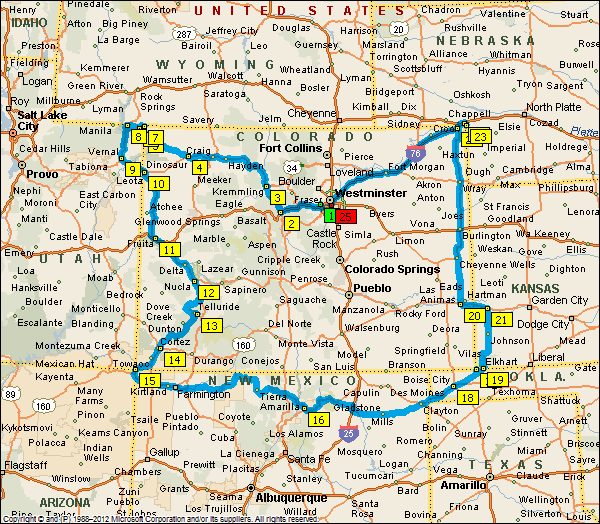
John's approximate planned route. |
Notes from John Coker, ride coordinator for the BMW Motorcycle Club of Colorado.
We had a good ride. It is definitely a four-day trip, not three as we originally thought. It took quite a bit
longer to get to the northwest corner due to about a mile of multiple mud holes. While you could do it in three
days, you would have to leave at sunup, minimize stops, and ride to dark or later and keep a pretty aggressive pace.
We had a big group of twelve with different riding styles, different rest stop and gas stop requirements. It would
be a lot more enjoyable and not have to be racing all of the time, and could stop for meals with four days.
We also hit bad weather Saturday afternoon that slowed us down, then stopped us early in Taos. Knowing that it was
not looking good to get to all four corners, and knowing the weather was going to be real bad Sunday afternoon on
the eastern plains, eight of the people headed home Sunday morning. Four of us went on to the southeast corner, then
started to hit bad weather and decided not to try to the northeast corner, so rode home though heavy winds, rains and
tornadoes. Did about 1650 miles. One change from the originally planned route was to ride US-64 from the southwest corner
through northern New Mexico.
We had one street bike, a BMW K1200, that was fine on the northwest dirt road to the corner turnoff. He parked it and rode
two-up the ten miles to the corner. He was also fine on the southeast corner dirt access roads. The rest were BMW 1200, 650
and 800 GS. All of the GS's made it to the nNorthwest corner.