
Whiskey Pass
|
Whiskey Pass |
Whiskey Pass - Costilla County - Colorado - 12,549 feet
El Valle Creek to west. Whiskey Creek to east.
Between San Luis and Stonewall.
On private property.
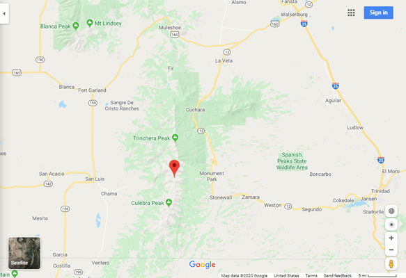
Google Maps |
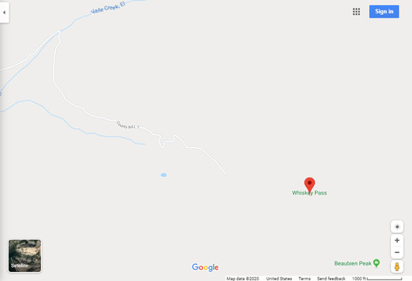
Google Maps |
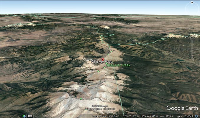
Google Earth |
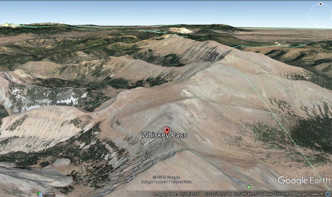
Google Earth |
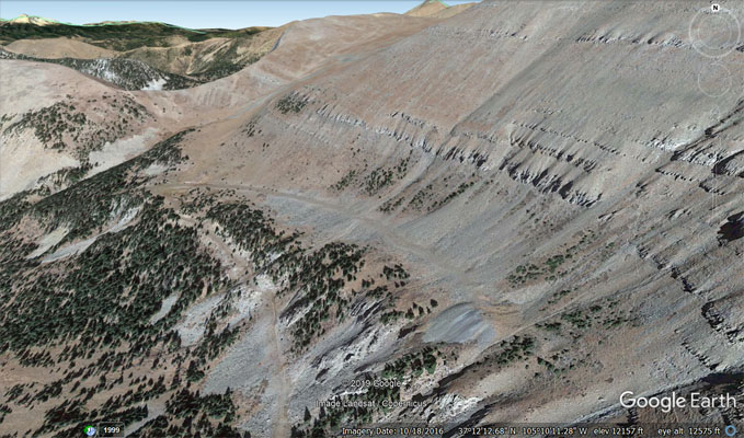
Google Earth, showing washout on west side. |
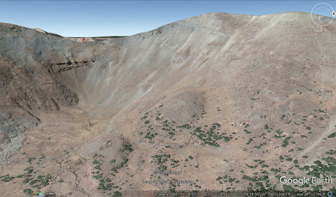
Google Earth, east side, looking west. |
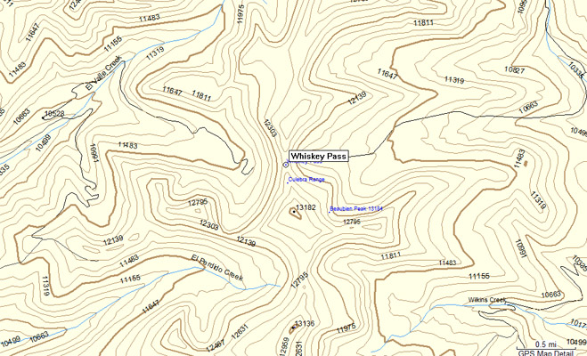
Garmin Mapsource |
For possible access to the Cielo Vista Ranch, check Cielo Vista Ranch.
From Sally Varner's excellent book "Crossing the High Divide, A Guide to 81 Passes 12,000 Feet & Higher in the Colorado
Rockies", published in 2010 by www.earthboundsports.com/:
...I decided not to attempt to reach Whiskey Pass and will wait for my trip to Culebra Pass until I have accumulated
the funding ($150) or access requirements change. I encourage the same for all enthusiastic "pass baggers" and hope you
can find some small satisfaction by driving to the closed gates, and looking longingly past them to the blue-green peaks
and passes ahead."
Notes from www.climb13ers.com:
Beaubien Peak is part of the vast Cielo Vista Ranch which is all private property. The ranch property line extends down
the west side of the central ridge of summits that stretch all the way from De Anza Peak in the north to State Line Peak in
the south. You can download a Google Earth map of the property by going to this link and scrolling on the right down to the GE
map link: https://www.mirrranchgroup.com/ranches/cielo-vista-ranch/. Permission must be obtained to access any of these peaks.
For several decades now, the owners of this ranch property have been the only ones to allow access to these high peaks. CF&I Steel
owns some of the land on the east side and has never agreed to any access and will prosecute trespassers. Policies by the ranch
owners have varied in the past regarding access to which summits and routes to them. Before attempting any peaks, make sure you
have a clear arrangement with the Cielo Vista Ranch owners/managers. See the "trailhead" description for more details.
Beaubien Peak from Whiskey Pass: This is probably the most likely access to be granted and also the easiest to this summit. Assuming
you can drive in 4WD vehicle to the car park for Whiskey Pass at 11,520 ft., you can attempt two possible routes that will eventually
converge at the summit of Beaubien.
Notes from 14ers.com:
Thu Aug 23, 2012 - Anyone have any information about Whiskey Creek Road off of CO 12 near Cucharas? Private, 2wd, 4wd, how high can you get?
Thu Aug 23, 2012 - If you mean Whiskey Pass Road, it is entirely on private property. I know of no means to gain permission to travel
this road, so good luck trying. The only way I know to get close, legally, is to summit Mt. Maxwell to the north, from a jeep road to the
North Purgatoire campground.
Fri Aug 24, 2012 - The west side is part of Cielo Vista, same owner as for Culebra. We were able to get a group permission through the ranch
last summer, I think there is a TR by Furthermore on this site. I am sure its too late to get a trip organized with them for this summer, but
try and give them a call next spring and see if they are offering trips up there again. The road is 4WD, but everyone in our group had stock
vehicles and seemed to do okay. There was one turn that we missed, and the wrong road got steep and nasty, but the correct road is stock 4x4
driveable. You can drive all the way to about 11,600' on the west, but of course only with permission from the ranch. The road has a washout
above that and cannot be driven to the pass.
Fri Aug 31, 2012 - The east side road to Whiskey Pass is driveable in your standard SUV to about the 11,000 foot level, but it's on private land
and access is restricted.
Notes from www.dangerousroads.org:
(The current YouTube video shows Saguaro cactus in the Sonoran Desert of Arizona.) Whiskey Pass is a high mountain pass at an elevation of
3.825m (12,549ft) above the sea level, located in Costilla County, Colorado, in USA. It's one of the highest mountain roads of Colorado.
The road to the summit, located within the Rocky Mountains, starts asphalted, but suddenly turns into gravel, rocky, tippy and bumpy at times.
It’s called Whiskey Pass Road (County Road L7). One mistake can have serious consequences. Road conditions are always changing. The road is
usually impassable from October to June (weather permitting). Avoid committing your vehicle to what is in front of you until you are sure of
what you are getting into because things could get worse. 4x4 vehicle with high clearance required. A traveler on this road must be experienced
and completely devoted to safe, slow and obstacle-conscious driving to deter danger. This is definitely not a Sunday drive. The steep drive will
take some skill, some patience, and some tolerance for vertigo.
| Feature Name | ID | Class | County | State | Latitude | Longitude | Ele(ft) | Map | BGN Date | Entry Date |
| Whiskey Pass | 193040 | Gap | Costilla | CO | 371208N | 1051003W | 12549 | El Valle Creek | - | 13-OCT-1978 |
| Whiskey Creek | 193052 | Stream | Costilla | CO | 371227N | 1050039W | 7943 | Stonewall | - | 13-OCT-1978 |
| nearby peaks | ||||||||||
| De Anza Peak | 196529 | Summit | Costilla | CO | 371327N | 1050933W | 13336 | El Valle Creek | 01-JAN-1972 | 01-AUG-1990 |
| Beaubein Peak | 196600 | Summit | Costilla | CO | 371148N | 1050959W | 13179 | El Valle Creek | 01-JAN-1972 | 01-AUG-1990 |
| Francisco Peak | 196595 | Summit | Costilla | CO | 371056N | 1050958W | 13149 | El Valle Creek | 01-JAN-1972 | 01-AUG-1990 |
| Lomo Liso Mountain | 2557493 | Summit | Costilla | CO | 371019N | 1051025W | 13136 | Trinchera Peak | 01-JAN-1972 | 29-MAY-2009 |
| Culebra Peak | 193131 | Summit | Costilla | CO | 370702N | 1051109W | 14039 | Culebra Peak | - | 13-OCT-1978 |
| Red Mountain | 193132 | Summit | Costilla | CO | 370644N | 1051052W | 13901 | Culebra Peak | - | 13-OCT-1978 |