Ride the Divide
15 Continental Divide Passes in one 24-hour, 1000-mile day
June 30 - July 1, 2001
|
Ride the Divide |
The Photos
(Click on the thumbnails to view the larger images.)
East side of Berthoud |
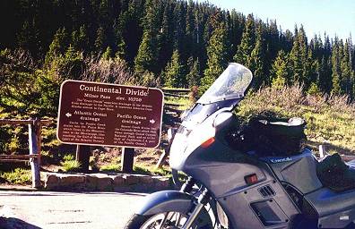
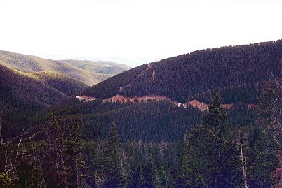
Berthoud |
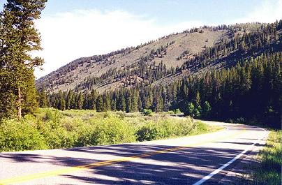
West side of Berthoud |
Milner |
East side of Willow Creek |
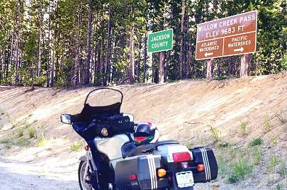
Willow Creek |
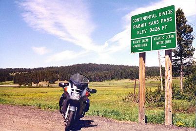
Rabbit Ears |
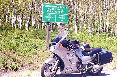
Muddy |
Eisenhower |
Loveland |
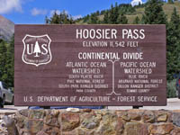
Hoosier |
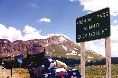
Fremont |
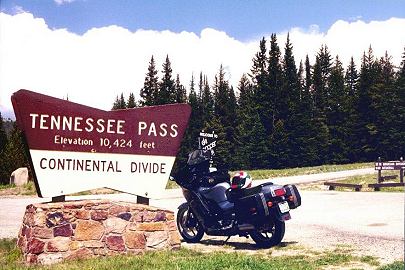
Tennessee |
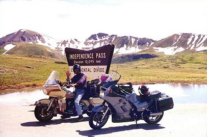
Independence |
East side of Independence |
East side of Independence |
Cottonwood |
East side of Cottonwood |
Monarch |
West side of Monarch |
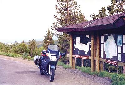
North Cochetopa |
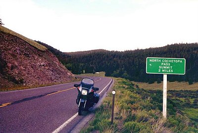
West side of N Cochetopa |
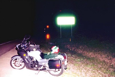
Spring Creek |
Wolf Creek |
The Story
Ride the Divide, a four-day rolling rally organized by Mark Folsom and his friends, was
one of the most popular Concours Owners Group rides held in Colorado. Even while enjoying the
pace of the RtD, I often wondered if all the paved passes over the Divide could be ridden in
one day, not necessarily avoiding up/down routes as RtD did. So with a little encouragement from a local
competitor in the Iron Butt Rally, I mapped a route and took off.
I left my home in Littleton, Colorado, about 6am on a sunny Saturday morning and headed west
into the mountains on I-70, enjoying the fresh scent of all the pine trees and the freedom of
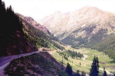
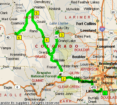
being out on the highway starting a long road trip. Past Idaho Springs I turned north to
travel up the winding road (losing some of its charm to a widening project) to Berthoud Pass,
my first photo stop of the day.
North from Berthoud I went past the Winter Park ski area, through Fraser (competes for the
coldest winter temperatures in the nation), and on to Granby where I took the turn to
Rocky Mountain National Park. Paid the $5 entry fee. The polite NPS gal looked at me and stated,
rather than asked, "You don't need a map do you?" Maybe the Aerostich and the intent look in my
eyes gave me away. After passing a few out-of-staters the road was clear all the way to Milner
Pass. What a scenic ride! The low rock walls along the edge of the road brought back memories of
childhood visits to the park. Then just a little ways up the road, at Far View Corner, was one
of the best vistas in all of Colorado. At Milner Pass, one that is easy to miss because it is
far below the heights that Trail Ridge Road reaches in a few miles, I took a photo and headed
back down, all the while maintaining a fairly conservative speed so I could take in all the
mountain beauty.
On the way out of the Park I stopped at the visitor center to stamp my National Parks Passport
book, then cruised past Shadow Mountain Reservoir, and headed back to Granby. From there I
headed north to travel along Willow Creek and to ride the almost perfect pavement and sweepers
up to Willow Creek Pass, one of my top three motorcycling passes. I continued north through
the forests to North Park and the fairly straight dash into Walden. Along the way I lost count
of all the prairie dogs. There are hundreds of them. Why do they stand on the road and run in
front of traffic? Don't they ever learn from others' mistakes? Anyway, after a very quick
helmet-on stop for gas at Walden I headed west through the wide-open valley for Muddy and Rabbit
Ears Passes. Took a couple of photos, exchanged waves with a group of bicyclists touring through
the area, and headed for Silverthorn.
South of the small town of Kremmling I was behind a truck setting up a pass when suddenly there
was something beside me on the right. It was a motorcycle. It was a Concours. It was my friend
Rick Hall! He and some other COG members were on their way to the COG National Rally in Oregon, had
stopped at the city park in Kremmling, had seen me go by, and Rick gave chase. We stopped to swap
howdies. The funny part is that on COG rides Rick will come up to me at a gas stop and loudly say
something like how much fun it was to have just ridden in from El Paso and wondering if we can
make it to Montana by dinner. Just to make the non-motorcyclists around the place
impressed, or to make them think we're nuts. So there we are beside the road, Rick is actually
on his way to Oregon, and I've already been on the Divide five times and am headed for ten
more. And there isn't anyone around to hear us. High altitude humor for sure.
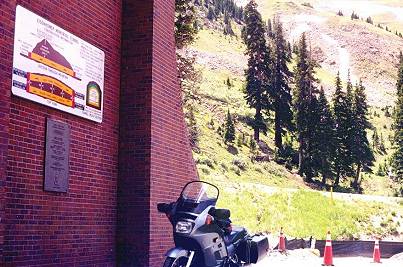
At Silverthorn I headed up I-70 to Eisenhower Tunnel and stopped to take a picture even though
it doesn't seem right to count going under the Divide. So I didn't count it. Just east
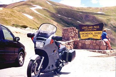
of the tunnel, I took US-6 up to Loveland Pass, snapped a photo, and headed back toward Lake
Dillon. Since most traffic is on I-70, it was a relaxing ride banking left and right through
the forest. I took Swan Mountain road, a shortcut around the south side of the lake (and
a very tough climb on a bicycle), and joined the summer tourist traffic heading to Breckenridge.
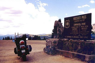
Avoided town traffic by taking side streets and continued on up to Hoosier Pass. Great views
from the top, but too much traffic, rough pavement, and too many 10-mph switchbacks. My least
favorite pass road to ride. Took a photo, headed back to Breck's side streets, and stopped for
gas and "lunch" (Gatorade and PowerBar).
In Frisco, one of my favorite resort mountain towns, it was time to hit I-70 again, at least
as far as to Copper Mountain, where I began the climb to Fremont Pass. Great road with passing
lanes. After a quick stop for a photo at the pass, the location of the impressive
Climax molybdenum mine, it was downhill along the headwaters of the Arkansas River toward
Leadville. At the east side of town I turned back north to get to Tennessee Pass where there are
a number of monuments honoring the 10th Mountain Division which trained during WWII at nearby
Camp Hale, then fought their way up through Italy. A quick photo and then a return to Leadville,
home of one the country's highest municipal airports at 10,000'. I continued to the south along
the Arkansas until reaching Twin Lakes.
The road from Twin Lakes to Independence Pass, while not one of the most favorite riding roads
because of traffic and pavement, is one of the most scenic stretches of road in Colorado. So
even though I was almost 500 miles into my trip, I sure was enjoying looking around. High
mountains to either side, a rushing emerald creek descending the valley, a curvy shelf road
high above the valley, snow fields round about, and finally the 12,095' pass (only the second
highest on this ride). After several photos at the pass and along the higher parts of the road,
I was on the move again back to Twin Lakes.
I continued on south to Buena Vista (pronounced Boona Vista by the locals, and often called
Puny Buny). And it's airport? Puny Buny Muni. Of course. At the traffic light I turned west to
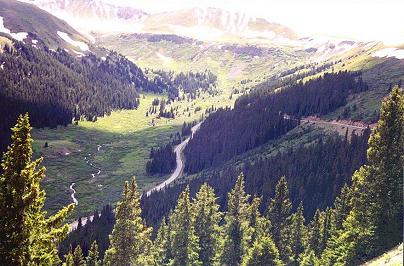
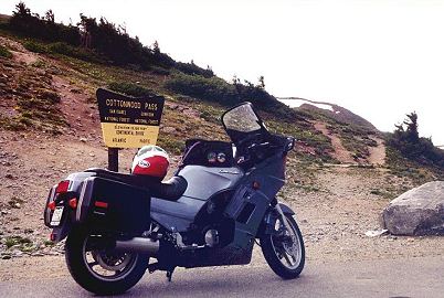
head up toward Cottonwood Pass on my favorite pass road of the day. It was paved just a few
years ago and isn't plowed in the winter. Great corners and scenery all the way to the 12,126'
summit! (Highest of the day in case you're counting.) An "insider's" road I probably really
shouldn't be sharing. On the way back down I wanted to take a short side trip to Spring Canyon,
a special place by Cottonwood Creek where our family has
spent a lot of time. But that would have to wait for another day. Just not enough time on this
ride.
From Buny, I continued on south to Poncha Springs to stop for gas and to refill the Camelbak.
While at the gas station a retired couple arrived in a purple Plymouth Prowler. Cool. And they
were on their way to the Black Hills for a Prowler gathering. Cool. A bunch of folks out in their
4-wheeled motorcycles enjoying the USA. After talking to a Christian brother who has been slowed
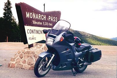
by a stroke, but is anxious to get back to motorcycling, I continued my journey towards Monarch
Pass. Another great road to ride, from either direction. Probably the fourth favorite pass of
the day. A photo, then down the west side and into the very pretty Gunnison River valley.
Eight miles east of Gunnison I headed south and east on CO-114, a back road that at first hugs
the edge of an irrigated valley (that is full of wild iris in the early summer) surrounded by
sage covered hills, then winds through a narrow canyon. At one point I had to slow while the big
horn sheep scampered away from the creek up to the safety of the cliffs. They are much smarter
than deer! After a ways the road opens up into rolling hills as it heads toward North Cochetopa
Pass (or North Pass, depending on the map). Upon reaching the summit I discovered there wasn't
a sign! Horrors, what would I do to show I was there? Take a photo of the kiosk? OK. And then a
picture of the "Pass 2 Miles" sign back down the road. OK. Back into the canyon. Big horns
scampered away again. Back through the valley. In 60 miles I had passed two semis and maybe met
a dozen cars. No traffic, nice curves, good pavement, plenty of scenery. In the top three for
sure!
By the time I reached Gunnison sunset was upon the land, so I gassed up again before heading
south towards Lake City. It was dark when I crossed the bridge over Blue Mesa Reservoir. I had
wanted to be able to see the great scenery as the road travels along Lake Fork but
I was about an hour behind where I thought I would be by then. As it was I was able to
catch glimpses of the ridgelines and the moon reflecting on the river. Not bad. At the very
quiet little town of Lake City I stopped in the darkness to put on another shirt. Headed out of
town, went through some sharp twisties as the road climbed toward Slumgullion Pass (isn't that
a neat name?), and occasionally saw the moon shining off Lake San Cristobal far below. After
what seemed to be quite a while, and actually was since I had slowed my pace so much since
sunset, I finally reached Spring Creek Pass. It sure was quiet stopped there in the dark on that
road that is mostly untraveled at night. Tick, tick, tick as the engine cools. Got out the
electronic flash and lit the night for a photo. (The sign can actually be read where it was
reflected somewhere in the SLR lens.)
On through the starlit night to the old mining town of Creede and a short stop to put on the
electric vest. Then south along the headwaters of the Rio Grande River (sometimes reflecting
the moon) to South Fork, a normally very busy junction town, but very quiet nearing midnight.
The "normal" tourists were probably in their rooms at the motels or sleeping in their RVs and
tents. But not an endurance rider, no sir'ee! Gassed up again. (Aren't pay-at-the-pump,
always-open stations a great invention?) It was now time for the 15th pass over the Divide, the
famous Wolf Creek Pass. And wouldn't you know? The road, as normal, was under construction.
(Does anyone know when it wasn't?) It was a little tough to follow that winding road with no
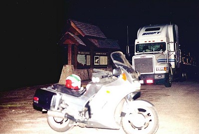
painted stripes on a dark night. Maybe I should get some PIAAs? At 12:30am, 18 1/2 hours after
leaving home I arrived at Wolf Creek, and there was a semi parked right in front of the sign
and kiosk. Bummer. Took out the electronic flash and lit the night, right there beside the
truck. No one yelled, so maybe the guy never noticed. Got back on the bike and in a very
relaxed mood, headed back through the construction to South Fork. It was still very quiet
there. Tourists still sleeping. Endurance rider still riding. Quiet pipes save lives.
What a great trip through God's creation. Fifteen times on the Continental Divide, over 1100
miles of beautiful Colorado scenery, and countless curves. It still brings a smile to my face as
I write this over three months later.
Ride safe, The Maps and Chart
![]() As I headed toward Monte Vista on mostly straight roads the sleepies began to arrive. Not
needing to be back home at any particular time, and still within the window for hitting 1000
miles in 24 hours as also planned, I decided to try the Iron Butt Motel for the first time.
Stopped at the National Forest Service office at the edge of town, parked behind one of their
vehicles, and laid down on the picnic table in a small courtyard. It was lit. It had flying
insects that bugged me. It was cold. I slept for an hour anyway and then hit the road.
As I headed toward Monte Vista on mostly straight roads the sleepies began to arrive. Not
needing to be back home at any particular time, and still within the window for hitting 1000
miles in 24 hours as also planned, I decided to try the Iron Butt Motel for the first time.
Stopped at the National Forest Service office at the edge of town, parked behind one of their
vehicles, and laid down on the picnic table in a small courtyard. It was lit. It had flying
insects that bugged me. It was cold. I slept for an hour anyway and then hit the road.
 Passed through Alamosa around 3am. Young folks were still out and about. But who was I to tell
them they should be at home sleeping? Went over La Veta Pass watching for deer. Didn't see any.
I was sleepy again by the time I got to Walsenburg so I found a safe looking place near the
visitor center and tried the Iron Butt Motel with side stand down, helmet on, seated on bike,
head down on the tank bag. Asleep in 15 seconds. Sound asleep. What a concept! Suddenly woke up
an hour later, fully alert, raised the kickstand, started the engine, roared away, all in about
10 seconds. Why? I don't know, but it kept me on schedule for a 1000-in-24. I gassed up at
a station by I-25 with the odometer reading exactly 1000 miles from home. Soon after getting
on the Interstate for the straight run back north the sun began to rise. Very nice. (Sunshine on my
shoulder ...) I stopped again in Pueblo for gas so I could document 1000+ in fewer than 24 hours.
(Although, since there aren't any date-time receipts available at the mountain passes, it
wouldn't really count for an Iron Butt SaddleSore anyway.) I visited a little while with a
couple of guys that had arrived from Arkansas during the night on a Gold Wing and a Venture,
then traveled on home, pulling into the driveway at 7:30am.
Passed through Alamosa around 3am. Young folks were still out and about. But who was I to tell
them they should be at home sleeping? Went over La Veta Pass watching for deer. Didn't see any.
I was sleepy again by the time I got to Walsenburg so I found a safe looking place near the
visitor center and tried the Iron Butt Motel with side stand down, helmet on, seated on bike,
head down on the tank bag. Asleep in 15 seconds. Sound asleep. What a concept! Suddenly woke up
an hour later, fully alert, raised the kickstand, started the engine, roared away, all in about
10 seconds. Why? I don't know, but it kept me on schedule for a 1000-in-24. I gassed up at
a station by I-25 with the odometer reading exactly 1000 miles from home. Soon after getting
on the Interstate for the straight run back north the sun began to rise. Very nice. (Sunshine on my
shoulder ...) I stopped again in Pueblo for gas so I could document 1000+ in fewer than 24 hours.
(Although, since there aren't any date-time receipts available at the mountain passes, it
wouldn't really count for an Iron Butt SaddleSore anyway.) I visited a little while with a
couple of guys that had arrived from Arkansas during the night on a Gold Wing and a Venture,
then traveled on home, pulling into the driveway at 7:30am.
Randy Bishop, Littleton Colorado, October 2001
(Click on the thumbnails to view the full-sized images.)
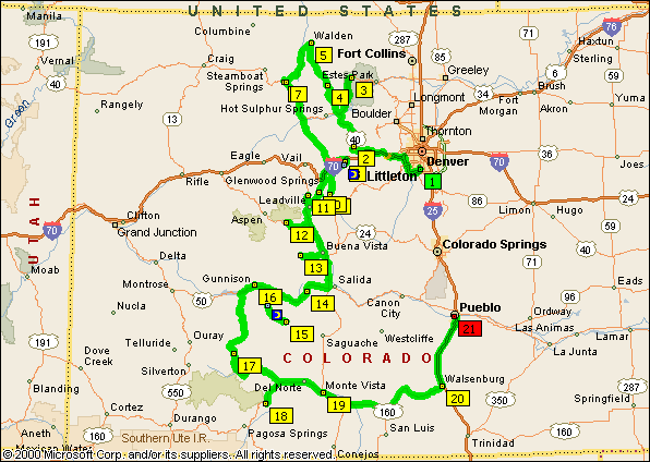
Littleton to Littleton, 1159 miles
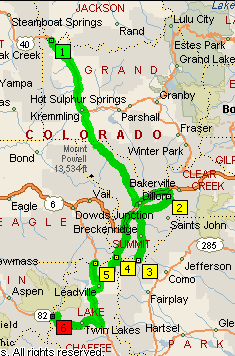
Littleton to Rabbit Ears, 251 miles
Muddy to Independence, 222 miles
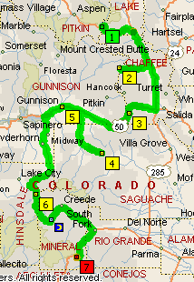
Independence to Wolf Creek, 380 miles
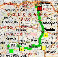
Wolf Creek to Littleton, 299 miles
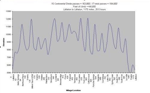
Approximate Climbs
The Log, June 30 - July 1, 2001
Time |
Odometer |
Miles from Start |
Location |
0554 |
58404 |
0 |
Littleton - fuel |
0655 |
58463 |
59 |
Berthoud Pass, 11,314' - north of Empire |
0820 |
58528 |
124 |
Milner Pass, 10,759' - Rocky Mtn Natl Park |
0940 |
58585 |
181 |
Willow Creek Pass, 9,683' - north of Granby |
1015 |
58617 |
213 |
Walden - fuel |
1050 |
58655 |
251 |
Rabbit Ears Pass, 9,426' - east of Steamboat |
1058 |
58658 |
254 |
Muddy Pass, 8,722' - east of Steamboat |
1212 |
58732 |
328 |
Eisenhower Tunnel, 11,013 - east of Silverthorn |
1222 |
58738 |
334 |
Loveland Pass, 11,990' - east of Dillon |
1316 |
58773 |
369 |
Hoosier Pass, 11,542' - south of Breckenridge |
1338 |
58784 |
380 |
Breckenridge - fuel |
1429 |
58811 |
407 |
Fremont Pass, 11,318' - south of Copper Mtn |
1450 |
58831 |
427 |
Tennessee Pass, 10,424' - north of Leadville |
1552 |
58880 |
478 |
Independence Pass, 12,095' - west of Twin Lakes |
1717 |
58943 |
539 |
Cottonwood Pass, 12,126' - west of Buena Vista |
1812 |
58987 |
583 |
Poncha Springs - fuel |
1840 |
59009 |
609 |
Monarch Pass, 11,312' - west of Poncha Springs |
1958 |
59071 |
667 |
North Cochetopa Pass, 10,149' - east of Gunnison |
2044 |
59111 |
707 |
Gunnison - fuel |
2244 |
59185 |
781 |
Spring Creek Pass, 10,898' - south of Lake City |
2358 |
59240 |
838 |
South Fork - fuel |
0030 |
59260 |
858 |
Wolf Creek Pass, 10.550' - west of South Fork |
0130 - 0230 |
59311 |
907 |
Monte Vista - Iron Butt Motel |
0400 - 0455 |
59400 |
998 |
Walsenburg - Iron Butt Motel |
0502 |
59404 |
1000 |
Walsenburg - fuel |
0542 |
59455 |
1051 |
Pueblo - fuel |
0739 |
59559 |
1159 |
Littleton - home |
|
|
|
-- Randy Bishop |